At Falcon Info Solutions, we’re revolutionizing how data is collected, analyzed, and applied through drone-powered solutions. Whether it’s mapping vast terrains, assessing crop health, or supporting defense operations — our drones deliver results faster, safer, and smarter. Trusted by ministries, corporations, and field experts alike, our drone services are built to meet high standards of performance and reliability.
Our Capabilities
What Our Drones Can Do!
From 3D terrain models to precision crop analytics — our drone systems are engineered for action.
1
Aerial Intelligence
Capture high-resolution imagery and topographic data from challenging terrains with first-person drone views.
2
Precision Mapping
Create 2D orthomosaic maps, 3D models, and digital twins to support infrastructure, agriculture, and environmental analysis.
3
Altitude Excellence
Operate efficiently even at high altitudes (over 2,000m+ ASL) — ideal for mountainous and remote projects.
4
Sensor Versatility
Equip drones with thermal, multispectral, and LiDAR payloads to customize data collection for any mission.
5
Custom-Built Drones
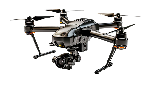
Designed and developed in-house, our drones are tailored to industry-specific requirements including defense, farming, and construction.
Our Highlights
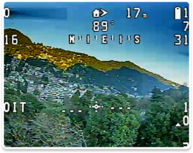
First-Person View of Nainital – Captured by a drone designed and developed by Falcon Info Solutions.
This isn’t just about reaching altitude – it’s about achieving excellence.
Flying at 2,183 meters above sea level (ASL) comes with its own set of challenges and we’ve conquered them through innovation, engineering, and determination.
Our Services
Our Drone Tech Solutions
End-to-end drone solutions for agriculture, infrastructure, defense, and beyond — tailored to meet business challenges. Trusted by Government, Ministry of Defence, Corporates and Professionals.
1
Aerial Survey
Accuracy from Above
We provide high-resolution drone surveys for land mapping, infrastructure monitoring, and topographic analysis — with unmatched precision.
At Falcon Info Solutions, our mission is to unlock the full potential of drone technology to transform how industries observe, analyze, and act on data. We aim to deliver precision, efficiency, and innovation through the following core services:
Smart
Agriculture
Empowering farmers with real-time insights into crop health, irrigation, and yield monitoring to enable smarter, data-driven decisions.
Building
Inspections
Conducting aerial assessments that enhance safety and coverage while minimizing human risk in structural evaluations.
Aerial Surveying
& Mapping
Delivering high-accuracy geospatial data for infrastructure development, urban planning, and land management.
3D Modeling &
Digital Twins
Creating immersive digital environments for simulation, analysis, and design through advanced aerial imaging.
Custom Drone
Design
Engineering UAV platforms tailored to specific industry needs—from endurance to payload—ensuring operational excellence.
Our Partners in DroneTech
We’ve had the privilege of working with forward-thinking organizations, government bodies, and global enterprises. Our collaborations in DroneTech span across sectors, driving innovation through smart tech solutions.
Let s Take Your Operations Sky-High
Are you Looking for custom drone services or want to start your aerial intelligence journey? Drones aren’t just cool tech – they’re the future of smarter decisions. If you’re ready to fly past limits and see results from above, we’re just one click away